GMDT completed the refurbishment of Morpeth Rail Station in February this year, and will be bringing the building back into use once #lockdown is over. So – it seems timely to post this article from the SENRUG website by John Earl relating the history of the railways in Morpeth.
If the North East is the cradle of the railways, South East Northumberland could certainly be considered the feeding-bottle, since it was at Killingworth Colliery, the site of which you can see as you travel into Newcastle from Morpeth, that George Stephenson developed the engines that he knew could pull both freight and passengers and make a national railway network possible. The whole area is criss-crossed with the tracks left by that era: from the wagonway at Plessey which is said to date back to the sixteenth century, and of which there is nothing left but a grassy mound across a field – to the remains of the Blyth and Tyne railway which at one time was set to be an alternative route to the North, and which is still in working order as a freight line.
Morpeth was always geographically well placed to be at the centre of this hub of railways, and at one time it was a major junction. The substantial range of stone buildings on the site testifies to a time when there were two major stations here, one the grand “through” station designed in ‘Scottish Baronial’ style, and the other the terminus for the Blyth and Tyne railway, which was the last of the old independent railways to be absorbed into the North Eastern Railway (in 1874). #
A third railway, the North British used to enter the town from the west. The course of this old railway can be traced west from the golf course, and eastwards through the town on old stone abutments that used to carry it into the Blyth and Tyne terminus. The North British wanted their own route through to Scotland rather than sharing with the York, Newcastle and Berwick which went straight through Morpeth up to Edinburgh. The idea of a main line across the moors to Hawick proved to be a bit of wishful thinking when the North British were faced with the actual receipts from passengers and freight, but that did not stop the line from staying open until the mid 1960’s.
Along the same route, until it diverged at Scots Gap, went the “Wannie Line” of local legend, a branch line that was again started as an alternative route to Scotland but which eventually only got as far as Rothbury. The trains on this picturesque route, which ran through one of the most sparsely populated areas of the country used to terminate behind the down platform on the west side of the station. You can still see the lines on this side, and the wider part of the bridge over the road that used to accommodate the branch line.
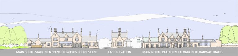
Morpeth`s station, a grand entrance to the town for visitors – recently refurbished and brought back into use by GMDT – was built in 1847 by Benjamin Green. Photographs of it in the early days show that it was built some way from the town centre at a time when there was little building in that direction. The famous ‘Morpeth curve’ to the south of the station was also forced on the railway engineers by the geographical position of the town, with a full ninety degree bend, requires an inevitable reduction in speed, much to the chagrin of railway timetablers ever since. In fact, it was a major bone of contention in the ‘Railway Races to the North’ of the 1890`s, the East Coast route complaining bitterly that they had a major disadvantage with the Morpeth curve on their line! It is certainly the severest curve on any main line in Britain. It has been the cause of three major and fatal accidents, in May 1969, March 1977 and in June 1984. And, in 1994. a mail train overturned on the curve. In the 1969 crash, the leading van of the train damaged part of the overall roof of the northbound platform. This could have been repaired, but instead was removed altogether, which is why only one platform has a canopy now.
So that is Morpeth as we see it today – though SENRUG would like to see the handsome and newly renovated station restored to become a junction serving Ashington, Bedlington, Blyth and Seaton Delaval
When visiting the station, look out especially for:
the North Eastern Railway tile map – one of the very few that still exist in situ – which shows the vast extent of the North East Railway`s network in the early 1900s;
the iron gates at the end of the subway which are pre-1923,
and the post box from the reign of Queen Victoria.
For more information on this topic, see Morpeth Antiquarian Society’s publication “Morpeth and the Railways” by Peter Carling with full detail and illustrations in its 48 pages, available now via the Society’s website and when shops reopen from Morpeth Chantry TIC.
And Morpeth Antiquarian Society’s publication “Morpeth and the Railways” by Peter Carling gives more detail and illustrations in its 48 pages, available now via the Society’s website and when shops reopen from Morpeth Chantry TIC.
I know that the remaining canopy at Motpeth station has six pointed stars within its iron decorationand have heard that these may be a symbol recognising a Jewish contribution to the railway being brought to Morpeth (I can only find remarks about busissmen persuading the railway to be routed via the town. I would be interested to hear any comments on what I have heard over the years. I understand the canopy dates from.1880 many years after the station first opened. Kind regards Craig.
Interesting article on the history of this grand station.
Is there a larger version of the elevations, as I would like to use it as a back scene on my model railway?